Olympic Barcelona as Urban Design: Montjuïc, Vila Olímpica and the Seafront Beyond Sports Memory

Updated
Barcelona’s Olympic deadline exposed an older urban argument
Barcelona’s 1992 Olympics are easy to remember as a sequence of images: the stadium ceremonies on Montjuïc, a white communications tower against the sky, two high-rise markers beside the Mediterranean, and a city newly confident in its public face. The countdown lasted six years; the disputes it compressed were much older. Those images are real, but they conceal the more consequential story. The Games mattered because they gave Barcelona a fixed date by which to coordinate projects that had different histories, different political origins and very different effects on the ground.
Before the Olympic transformation, the city did not possess one coherent relationship with either Montjuïc or the eastern waterfront. Montjuïc already held a stadium from 1929 and other major civic facilities, but it was not yet the concentrated architectural ensemble associated with 1992. Along the coast east of the old city, railway infrastructure, industrial properties and fragmented access separated large parts of Barcelona from the sea. In Nova Icària, the future site of Vila Olímpica, deteriorated buildings, self-built homes, factories and weak infrastructure coexisted inside a working-class district whose physical disorder was also a form of social history. The problem was therefore not simply that Barcelona lacked attractive venues. The city had inherited discontinuities: between old facilities and new uses, between neighborhoods and the coast, between industrial land and residential demand, and between metropolitan movement and local public space.
The Olympic project addressed those discontinuities through several distinct techniques. On Montjuïc, it reused and reframed existing monuments while adding conspicuous new buildings. Between the mountain and the seafront, it accelerated road, rail and public-realm interventions that changed how land connected across the city. At Vila Olímpica, it replaced much of an existing industrial-residential fabric with a planned neighborhood. At Port Olímpic, it combined marine infrastructure, leisure, architecture and a new urban image, then left later governments to repair weaknesses in access, governance and everyday use.
This produces the central interpretive question: was Barcelona 1992 a successful act of urban integration, or an event-led redevelopment that converted socially complex land into a more marketable city? A defensible answer must hold both possibilities in view. The Olympic works opened beaches, created parks, connected infrastructure and gave Barcelona new civic rooms. They also demolished industrial heritage, displaced existing uses and delivered housing whose social reach was narrower than early public ambitions suggested. The legacy is not one verdict because the city was not transformed by one method.
For travelers who already know Barcelona through Gaudí, reading the Olympic city changes the scale of attention. The subject is no longer a singular building but the relationship among plans, roads, blocks, open spaces and land values. A useful companion is a Barcelona architecture day beyond Gaudí, but the Olympic sequence requires a wider lens: it asks how a city uses design to change its own geography.
Montjuïc: continuity was designed as carefully as novelty
The old stadium was not treated as an obstacle
Montjuïc is the right place to begin because it complicates the idea that Olympic Barcelona was created from nothing. The mountain’s principal stadium already existed. According to the institutional overview of the Montjuïc Olympic Ring, the stadium built in 1929 was extensively remodeled for the 1992 Olympic and Paralympic Games while its façade was retained. That decision is more than a conservation footnote. It shows how the Olympic city manufactured continuity: the exterior could carry civic memory and monumental authority, while the interior was remade for a new technical and ceremonial program.
Retaining the façade did not preserve the stadium as an untouched historical object. It turned the older envelope into a frame for a new event. This distinction matters when reading the building on site. The stone exterior suggests inheritance, stability and institutional depth; the transformed interior belongs to a late twentieth-century system of spectatorship, broadcasting, security and large-scale performance. The building therefore stages two time periods at once. It is neither a pure restoration nor a clean replacement. It is an example of adaptive monumentality, in which a city keeps the legible part of an earlier civic image while changing what that image must do.
That approach separates Montjuïc from Vila Olímpica. On the mountain, the Olympic intervention could claim legitimacy through visible continuity. On the coast, much of the previous fabric would disappear. The contrast is one of the most important pieces of evidence in the whole route: heritage was not governed by a single Olympic doctrine. It was preserved when it strengthened the desired public composition, and it was more vulnerable when it occupied land needed for a new urban system.
A constellation of authors, not one architectural language
The Olympic Ring surrounds the inherited stadium with buildings that do not pretend to share one style. Arata Isozaki’s Palau Sant Jordi presents a broad, technologically assured roof form. Santiago Calatrava’s communications tower is a vertical emblem, closer to a sculptural piece of infrastructure than to a conventional building. Ricard Bofill’s INEFC building uses a more explicit classical vocabulary. The Bernat Picornell pools, inaugurated in 1970 and remodeled for 1992, add another layer of reuse. These authors and interventions are all named in the same institutional account, yet their coexistence is more revealing than any one object.
The Ring’s unity comes from landscape, spacing and ceremonial sequence rather than stylistic consistency. The buildings are set apart so that each can act as an identifiable figure. Between them, large open areas manage arrival, gathering, orientation and the visual drama of a major public event. This is urban design through controlled distance. The voids are not leftover space; they allow monumental buildings to be seen, separated and remembered.
That strategy has a double effect. During a large event, the scale can feel purposeful because crowds animate the distances. Outside that condition, the same spaces reveal how strongly the ensemble was designed around episodic intensity rather than continuous street life. This is not necessarily a failure. A stadium district cannot be judged by the criteria of a dense residential quarter. But it does mean that Montjuïc’s public realm operates differently from an Eixample street or a Poblenou block. It is civic landscape at metropolitan scale, not an everyday neighborhood fabric.
The buildings also distribute architectural authorship across international and Catalan figures. Isozaki provides a globally legible arena; Calatrava supplies an instantly recognizable skyline object; Bofill invokes a monumental Mediterranean classicism; the retained stadium façade anchors the composition in an earlier civic Barcelona. The result is an edited panorama of late twentieth-century institutional architecture. It tells visitors that the city can be modern without erasing every prior layer, and cosmopolitan without adopting one house style.
For a fuller Montjuïc day that gives equal weight to landscape and cultural institutions, see a focused Montjuïc visit built around art, views or gardens. The Olympic Ring deserves a different kind of concentration: rather than asking which building is most beautiful, ask how the spaces between buildings turn separate commissions into one political image.
The mountain made the Games look like a civic inheritance
Montjuïc carried symbolic advantages that a wholly new suburban site could not provide. Its elevation offered a commanding relationship with the city. Its existing stadium allowed the Games to appear connected to Barcelona’s earlier public ambitions. Its open land could absorb venues and crowd space without forcing the same degree of residential replacement seen at the waterfront. The Olympic center therefore presented transformation as a continuation of civic history, even while much of the wider project represented a sharp break with inherited land uses.
This is why the mountain should not be reduced to a list of sports buildings. It is the ceremonial argument of the Olympic plan. The ensemble says that Barcelona’s modernity is rooted, composed and public. It also demonstrates a recurrent planning tactic: concentrate symbolic architecture where topography and existing monuments can magnify it, while using less glamorous infrastructure elsewhere to make the whole system function.
Montjuïc’s Olympic layer also sits beside memories that are not celebratory. The mountain carries political, military, labor and cultural histories beyond 1992. A reader interested in how physical sites hold those harder narratives can continue with Barcelona’s Civil War memory through physical evidence. Keeping those layers in view prevents the Olympic Ring from becoming an isolated success story. It is one episode in a much longer history of the city using Montjuïc to stage power, memory and public identity.
The most transformative Olympic architecture was often infrastructure
The distance between Montjuïc and Vila Olímpica is not empty space between two attractions. It is where the Olympic project becomes a city system. The Games accelerated interventions in roads, railways, airport capacity and major junctions. The institutional Ring account connects the Olympic transformation to the Ronda Litoral, the Ronda de Dalt, Glòries and additional airport terminals. Camerin’s study of Poblenou likewise emphasizes the publicly financed infrastructure that made the eastern waterfront available for new development, including the Ronda Litoral, the remade beaches and the removal or burial of coastal railway barriers.
These works changed more than travel times. Infrastructure altered which land could be treated as central, developable and publicly accessible. A railway line at the edge of the water is not merely a transport object; it is also a boundary between neighborhood and coast. Burying or removing it changes the value of adjacent plots, the continuity of streets and the possibility of beaches and parks. A ring road can divert movement from central streets, but it can also create new barriers or release new development fronts depending on its section and relationship to the ground. Olympic Barcelona should therefore be read as a reorganization of urban potential.
This is one reason the familiar phrase that Barcelona “opened to the sea” needs scrutiny. It accurately describes an enormous civic gain: residents received a far more continuous coastal public realm, new beaches and a stronger visual and physical relationship with the Mediterranean. Yet “opening” also involved closing other histories. Industrial and railway uses were removed; land was reclassified; existing residents and small enterprises did not necessarily benefit from the new values created around them. The same intervention can be public-space improvement and property-market transformation at once.
The Olympic deadline made coordination possible because the projects could be justified as parts of one urgent program. Roads supported venue access. Rail changes supported new housing and beaches. The new neighborhood housed athletes before entering the residential market. The port served sailing competitions while completing the maritime image. Each component had an Olympic function, but its lasting purpose was urban. This is the decisive shift from sports memory to planning analysis: the venues were temporary centers of attention, while the altered ground conditions continued to shape Barcelona afterward.
The infrastructure also helps explain why Barcelona’s Olympic legacy became so influential internationally. The city did not rely on one spectacular stadium surrounded by parking. It distributed investment across visible architecture and less photogenic systems. That made the event legible as a metropolitan upgrade. Yet the model is difficult to copy because its apparent coherence depended on decades of prior plans, available redevelopment land, strong municipal design culture and a political moment capable of aligning institutions. The six-year countdown did not create all the ideas. It selected, accelerated and joined them.
Vila Olímpica: a new neighborhood built through both repair and erasure
Nova Icària was not an empty site
The strongest misconception about Vila Olímpica is that it simply replaced obsolete factories on vacant land. The area was physically degraded and poorly serviced in important respects, but it was not socially blank. Federico Camerin’s scholarly study of Poblenou’s redevelopment describes 1980s Nova Icària as a place of deteriorated buildings, self-built housing, weak infrastructure and neighboring uses that planners considered incompatible with residence. It also stresses that those same conditions had supported a working-class community over time. The urban problem was therefore real, but so was the life embedded within it.
This distinction changes how the Olympic Village should be judged. Calling the area a void makes comprehensive redevelopment appear inevitable. Calling it a neighborhood makes demolition a political choice with distributive consequences. Both descriptions contain evidence: low-density industrial and railway land created an opportunity for large-scale planning, while homes, workshops and local routines meant the land was already inhabited and productive. The conflict lies in which evidence the plan allowed to shape the future.
Poblenou’s earlier development helps explain the complexity. Industry had grown along routes such as Pere IV and around the railway, bringing factories, modest housing and labor organization into close proximity. As industrial activity declined or relocated, buildings deteriorated and uncertainty discouraged reinvestment. Yet decline was not purely natural. Long-running redevelopment expectations also made the area provisional. When owners, residents and public authorities believe major clearance may come, maintenance decisions change. By the 1980s, degradation became both a condition to address and an argument for intervention.
The Olympic plan revived a much older waterfront ambition
Vila Olímpica did not emerge from a six-year burst of imagination. Its lineage reaches back to the Ribera Plan, developed from the mid-1960s and formalized in the early 1970s around the redevelopment of industrial and railway land along the coast. Camerin presents that plan as closely aligned with large landowners and speculative interests. It met political and social opposition, and an alternative ideas competition coordinated by Manuel de Solà-Morales proposed a response more attentive to the existing population. The original Ribera scheme was not implemented, owing to both opposition and unfavorable economic conditions.
After the transition to democracy, the 1976 Metropolitan General Plan continued to identify the coastal sector as an area for urban renewal while retaining Poblenou’s broader industrial role. The Olympic candidacy then reactivated part of the waterfront ambition under a different political regime and a different public narrative. On 26 July 1986, shortly before Barcelona was selected to host the Games, the special plan for the seafront sector around Carles I and Avinguda d’Icària was approved. Vila Olímpica SA, or VOSA, managed planning and land assembly; Nova Icària SA, or NISA, handled architectural development. The related 1987 municipal framework of Àrees de nova centralitat, or Areas of New Centrality, is crucial: Nova Icària was no longer to be treated as a remote industrial margin but as a strategic node capable of shifting investment, housing and public attention eastward.
The continuity between the Ribera Plan and the Olympic Village is important, but it should not be flattened into an accusation that nothing changed between dictatorship and democracy. The democratic city delivered major public infrastructure, parks and beaches, and it framed the project as a metropolitan civic improvement rather than only a landowners’ scheme. At the same time, the persistence of the same redevelopment territory shows how planning ideas can survive political transitions. A new government may reject an old plan’s institutions and rhetoric while still inheriting its diagnosis of which land should be cleared and made more valuable.
The master-planning role belonged to MBM Arquitectes—Josep Martorell, Oriol Bohigas and David Mackay—with Albert Puigdomènech. Their task was not merely to design athlete accommodation. It was to produce a permanent piece of city that could first serve the Games and then become a residential district. That dual use is central to the Barcelona approach. The temporary program helped finance and accelerate a lasting neighborhood, while the permanent market gave the Olympic Village a post-event rationale.
The block became the instrument of normalization
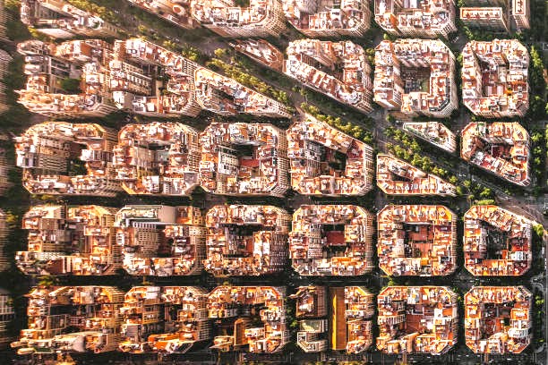
Vila Olímpica’s urban form can be read as an attempt to make the waterfront belong to Barcelona rather than remain a detached enclave. The plan extended a recognizable street-and-block logic toward the coast, using perimeter buildings, interior spaces, commercial fronts and a hierarchy of avenues and parks. It did not simply repeat Ildefons Cerdà’s Eixample block, but it invoked the authority of Barcelona’s gridded urban tradition. That made the new district feel like an expansion of the city rather than an isolated athletes’ compound.
This was a design achievement. Many Olympic Villages struggle after the event because their buildings and open spaces were conceived for temporary security, unusual occupancy and institutional management. Vila Olímpica was planned for conversion into ordinary housing. Its streets, ground floors and public spaces were intended to support a permanent neighborhood. The success of that transition helps explain why the district is often cited as evidence that mega-event investment can be turned into usable urban fabric.
Yet the block also normalized a radical break. Once the new grid, parks and residential buildings were complete, it became difficult to perceive the industrial-residential landscape they replaced. A coherent plan can naturalize its own arrival. The streets seem inevitable because they connect well; the open spaces seem unquestionably public because they are accessible; the seafront seems as though it had always been meant for recreation. The design’s legibility makes the prior complexity less visible.
This is where a close reading of surviving fragments matters. Camerin notes that the Can Folch chimney was preserved while much of the surrounding industrial architecture disappeared. A chimney can function as memory, landmark and visual contrast, but an isolated object cannot communicate the full relationships of a working industrial district. It loses the yards, sheds, machinery, housing and labor routines that once gave it meaning. Preservation becomes symbolic rather than systemic.
The heritage tradeoff is therefore not simply “old factories versus new homes.” Some structures were in poor condition; some uses were environmentally and spatially incompatible with better housing; public access to the coast was a major gain. The harder question is whether more of the industrial fabric, street pattern or social history could have been integrated into the new district. Vila Olímpica stands as a particularly comprehensive moment of clearance, one in which a new neighborhood was made legible partly by reducing the visual competition of what came before.
Housing revealed the limits of the public-space success
The district’s public realm and its housing outcomes should be evaluated separately. The Olympic works produced beaches, parks, broad pedestrian spaces and a new connection between city and sea. Camerin identifies the long waterfront park along Avinguda Litoral by Manuel Ruisánchez and Xavier Vendrell as one of the intervention’s concrete improvements. These are collective assets whose value extends beyond residents of the immediate neighborhood. They changed how Barcelonians could use the coast and helped establish public space as the most admired part of the city’s post-dictatorship urban identity.
Housing followed a more selective trajectory. Camerin’s critical account emphasizes the gap between early social-housing intentions and the eventual market positioning of the completed homes. The district became a desirable residential environment, but desirability is not the same as social inclusion. When publicly enabled redevelopment creates high-quality streets and open space yet the adjoining homes are inaccessible to many of the people displaced or priced out by the change, the project’s civic benefits are real but unevenly distributed.
This tension is essential because it prevents two easy conclusions. It would be inaccurate to dismiss Vila Olímpica as merely privatized redevelopment: the beaches and parks are substantial public achievements, and the neighborhood solved genuine infrastructural problems. It would be equally incomplete to celebrate the public realm without asking who could remain, return or buy into the new residential district. Urban design can widen access to one resource—the sea—while narrowing access to another—housing in the transformed area.
The best evidence is spatial. Move from the neighborhood streets toward the waterfront and notice how smoothly the district presents its urban order. Then ask what is absent from that order. The missing industrial texture is not visible unless it is explained; the social history cannot be reconstructed from the surviving chimney alone; the market transition is not legible in the paving. Vila Olímpica is persuasive precisely because the new city is so coherent. Specialist interpretation must recover the conflict that coherence has hidden.
The evidence for Olympic Barcelona is dispersed across a mountain ensemble, buried infrastructure, residential blocks, beaches and a working port. A private specialist is most useful here when the route holds one argument across those separate sites: selective reuse on Montjuïc, comprehensive replacement at Vila Olímpica and later correction at Port Olímpic. That is the purpose of private Barcelona tours shaped around a specialist urban-design brief, rather than a recital of venue history. Inquire now to request a Barcelona route centered on architecture, planning, housing and the seafront transformation.
Port Olímpic: the first design created an icon, the second questioned its urban fit
A marina, a skyline and a new public image
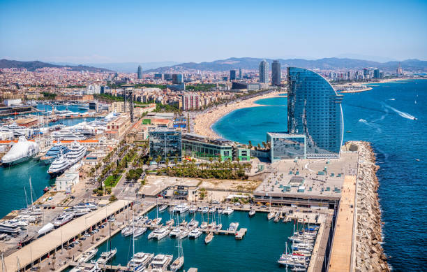
Port Olímpic completed the maritime composition by giving the transformed waterfront a recognizable center. the municipal history of Port Olímpic states that the port was built in 1990 for the 1992 sailing competitions and credits Oriol Bohigas, Josep Martorell, David Mackay and Albert Puigdomènech. It sits between Somorrostro and Nova Icària beaches, faces Vila Olímpica and is framed by Torre Mapfre, Hotel Arts and Frank Gehry’s fish sculpture.
That arrangement made the port more than a technical facility. The towers gave the seafront a vertical gateway visible from a distance. Gehry’s reflective fish provided a lower, more animated emblem. The marina and beaches brought water into the everyday image of Barcelona. Together they created a postcard composition that could stand for the entire Olympic transformation: international architecture, leisure, public coast and a city turned outward.
The composition also reveals how closely the public and commercial dimensions of the project were intertwined. Beaches and promenades expanded collective access. Hotels, offices, dining and marina uses helped finance and animate the new district. The port’s urban role depended on this mixture, but the balance was never guaranteed. A waterfront can be publicly accessible while still being shaped by highly managed consumption. It can feel open from the promenade yet disconnected from adjacent neighborhood streets. Design establishes an initial relationship; management and use determine how that relationship evolves.
The later planning diagnosis is part of the Olympic legacy
A useful reading of Port Olímpic does not stop in 1992. The need to rethink the port a generation later is evidence about the first scheme. Barcelona Regional’s 2017–2018 strategic record, prepared for Barcelona City Council, observed that over roughly twenty-five years the port had become strongly associated with dining and nightlife, while poor accessibility and connectivity had obscured its primary port function in the eyes of residents. The document proposed stronger integration with the city, a different mix of uses and a direct municipal management model.
This later diagnosis should not be used as proof that Port Olímpic failed. Urban infrastructure changes as patterns of use, expectations and governance change. A port designed under an Olympic deadline can require adaptation after decades of commercial operation. The significant point is that access and civic integration—central promises of the 1992 waterfront story—had to be addressed again at the very site meant to symbolize Barcelona’s reconnection with the sea.
The second-generation plan therefore acts as a critique in built-policy form. It asks whether the port serves residents as a maritime civic space, whether its level changes and connections support continuity with Vila Olímpica and the beaches, whether boating retains a meaningful role, and whether the economic program produces public value beyond consumption. Those questions are not external commentary imposed by academics. They were embedded in the city’s own strategic reconsideration of the port.
This creates a productive contrast with Montjuïc. The Olympic Ring’s main heritage question concerns how old and new monuments were composed. Port Olímpic’s question concerns adaptability: can a purpose-built event infrastructure become an ordinary and inclusive part of the city? The answer depends less on preserving an original architectural image than on revising access, uses and governance when the first model proves too narrow.
To place Port Olímpic within Barcelona’s longer relationship with the water, continue with a guide to Drassanes, Port Vell and Barceloneta as competing maritime narratives. The Olympic port belongs to that larger story, but it represents a particular moment when the city used a mega-event to convert the Mediterranean edge into a global urban image.
How to read the Olympic sequence as one geographic argument
The three principal areas are far enough apart that they should be treated as linked chapters, not as one continuous architectural walk. Barcelona’s municipal Geoportal provides the most useful common spatial frame: locate the Montjuïc Olympic Ring, Vila Olímpica, Port Olímpic and the coastal edge together before examining individual buildings. The map makes the basic planning fact visible. Barcelona did not build one Olympic precinct; it used the Games to connect dispersed urban operations.
First chapter: read Montjuïc through age, authorship and void
At the Olympic Ring, begin with the difference between inherited and new fabric. The retained stadium façade is evidence of selective continuity. Palau Sant Jordi, the Calatrava tower and the INEFC building show how multiple authors were assembled into a civic composition. The open areas between them reveal the scale of ceremonial planning. Three questions keep the visit analytical: which elements claim historical legitimacy, which announce technological modernity, and how does the landscape make unrelated architectures appear to belong together?
Do not judge the Ring only by façade detail. The urban subject is the sequence of approach, separation and sightline. A photograph of the tower may capture an icon; the site explains why the icon works. It rises within a low, open composition where verticality has exceptional force. Palau Sant Jordi’s broad roof reads differently because the surrounding void lets its profile become landscape. The stadium façade gains authority because it anchors the newer forms with masonry continuity.
Second chapter: treat the journey east as evidence, not dead time
The cross-city movement from Montjuïc to Vila Olímpica should be understood conceptually even when the intermediate infrastructure is not examined stop by stop. The route links a mountain ceremonial center to a coastal residential project. Between them lie the systems that allowed the transformation to function: ring roads, rail changes, major junctions and the reorganization of access to the waterfront. The shift in urban grain—from monumental campus to dense city and then to planned seafront blocks—is itself part of the argument.
This is also where Barcelona’s broader twentieth-century design story helps. Olympic planning did not replace the city’s earlier design cultures; it drew on them. The authority of the Eixample block, the modern architectural legacy associated with Montjuïc and the democratic-era emphasis on public space all informed the way 1992 could be presented as distinctly Barcelonan rather than as an imported event package.
Third chapter: enter Vila Olímpica from the city side
At Vila Olímpica, begin away from the beach. Read the residential streets, block edges and ground-floor relationships before allowing the seafront to dominate attention. This order matters because the district’s strongest public image—the Mediterranean—can conceal the planning work required to produce a permanent neighborhood. Look for how avenues carry the city grid toward the water, how open spaces interrupt or extend the blocks, and how the district manages the transition from housing to landscape.
Then identify the fragments and absences. The surviving industrial chimney is useful precisely because it is insufficient. Ask what kind of memory can survive when an object remains but its spatial and social setting disappears. Compare that condition with the stadium façade on Montjuïc. Both are preserved fragments, but they perform opposite roles. The stadium façade organizes the new ensemble and retains institutional continuity; the chimney testifies to a world that the new plan largely removed.
Final chapter: examine Port Olímpic as an interface
At Port Olímpic, the key relationship is not one building but the meeting of neighborhood, road infrastructure, quays and beaches. Read the towers and Gehry’s fish as image-making devices, then shift attention to ground level. How does the port connect to Vila Olímpica? Where does public promenade become managed marina space? Which routes feel continuous with the beaches, and which reveal the specialized geometry of a port?
Because the port has been subject to later redesign and management change, distinguish original Olympic intentions from subsequent corrections. The 1990 port established the location, marine basin and iconic frame. Later strategy addressed the social return, accessibility and balance of uses. Conflating the two periods would make the legacy appear either more seamless or more defective than it was. The site is valuable because it shows urban design as an ongoing process rather than a finished 1992 artifact.
Three forms of Olympic urbanism produced three kinds of legacy
Montjuïc, Vila Olímpica and Port Olímpic should not be scored as versions of the same project. They represent different relationships to what existed before, and that difference explains why their legacies diverge.
- Montjuïc used selective continuity. The Olympic intervention retained a monumental façade, remodeled facilities and inserted new architecture into a landscape capable of unifying diverse objects. Its strength is symbolic coherence. Its limitation is that a ceremonial district cannot by itself produce the continuous social life of a neighborhood.
- Vila Olímpica used comprehensive replacement. It solved infrastructure and access problems, created a permanent residential quarter and helped deliver beaches and parks. Its cost was the loss of much industrial-residential fabric and a housing outcome less socially inclusive than the public-space narrative might imply.
- Port Olímpic used purpose-built maritime infrastructure and image. It gave the seafront a recognizable center and supported the Olympic sailing program. Its later strategic revision shows that iconic visibility does not guarantee everyday integration, accessible connections or an enduring balance of uses.
The celebratory reading of Barcelona 1992 is supported by substantial evidence. The city gained high-quality public space, better metropolitan connections, a dramatically improved seafront and facilities that continued to serve public and cultural life. The Games were used as a deadline for projects with durable urban value rather than as an excuse for a single isolated stadium. This was an achievement of planning coordination as much as architecture.
The critical reading is also supported. The waterfront transformation converted low-value industrial and railway land into prestigious residential, commercial and leisure space. Existing communities and productive landscapes had limited power over the final form. Heritage was often reduced to fragments. Public investment created value that did not translate into equally broad housing access. Later problems at Port Olímpic demonstrated that an open-looking waterfront can still require substantial work to become well connected and civically balanced.
These readings are not mutually exclusive because they address different distributions of benefit. A beach can be a genuine public good even if adjacent redevelopment accelerates exclusion. A new road can improve metropolitan movement while increasing development pressure. A preserved façade can protect memory while disguising how completely the building behind it changed. Urban projects operate through such combinations. Demanding that Olympic Barcelona be either triumph or failure makes the city less intelligible.
The most persuasive interpretation is that 1992 transformed Barcelona by aligning infrastructure, public space, architecture and real-estate development under one deadline. That alignment was unusually effective, but effectiveness is not the same as neutrality. The city gained the capacity to act at metropolitan scale. It also demonstrated how quickly a socially complex territory could be redescribed as obsolete, cleared and returned as a more valuable urban product.
The seafront is the achievement; the missing city is the warning
Seen from Montjuïc to Port Olímpic, the Olympic transformation is best understood as a change in Barcelona’s urban orientation. The mountain supplied ceremony and continuity. The transport and rail works altered what could connect. Vila Olímpica turned a former industrial-residential sector into a planned extension of the city. The port and beaches made the Mediterranean a central public image rather than a blocked industrial edge.
The route also reveals that “opening the city to the sea” was never a purely spatial act. It required decisions about which histories to retain, which land uses to remove, which residents the new housing would serve and how public investment would generate private value. The beach is visible; the displaced workshops and homes are not. The stadium façade survives as civic memory; the Can Folch chimney survives as evidence of a context largely gone. The contrast is the interpretive payoff.
Barcelona 1992 deserves its reputation because the projects were not confined to sports memory. They reshaped systems that still organize the city: metropolitan movement, the relationship between neighborhoods and water, the role of public space, and the use of architecture as a form of civic identity. The more demanding lesson is that good urban design can produce collective benefit and exclusion at the same time. Quality does not cancel conflict.
That is why the Olympic city remains worth studying in person. Its most important evidence is not a medal venue or a skyline photograph. It is the difference among three forms of transformation: an old monument carefully repurposed, a neighborhood comprehensively remade, and a port redesigned again when its first urban model proved incomplete. Together they show Barcelona at its most capable—and make visible the price of treating a living city as a project that must be finished on time.
If you’re interested in any private tours of Barcelona, please reach out to us.








 So if you are looking for the absolute best in Barcelona & surroundings with authentic local fully-licensed native guides whose English you can actually understand and with an exclusive and amazingly fun itinerary