Cerdà’s Barcelona in Plan and Street: Chamfers, Courtyards and the Unfinished Social Logic of the Eixample

Updated
A corner cut away from the square
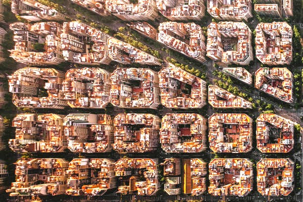
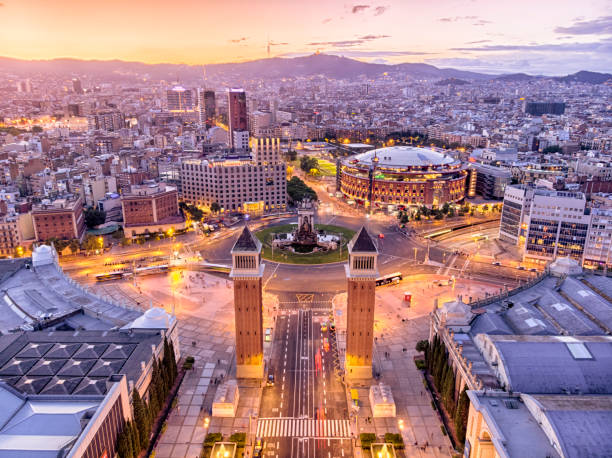
Begin with an ordinary Eixample crossing rather than a celebrated façade. At the junction of Roger de Llúria and Diputació, each building stops short of the right angle that a square grid appears to promise. Four diagonal fronts face one another across an enlarged intersection. Seen from above, the block is not a square but an octagon; seen from the pavement, the cut corner opens more sky, lengthens sightlines and turns the crossing into a small urban room. Barcelona calls the form a xamfrà, or chamfer. It is the most immediately visible fragment of Ildefons Cerdà’s planning intelligence, but it is also one of the easiest to misunderstand.
The chamfer was not conceived as a decorative frame for architecture. It belonged to a system joining movement, visibility, light, ventilation and the repeated geometry of the block. Its later uses have been more various: turning space, loading area, parking edge, café terrace, taxi rank, bicycle cluster, meeting point, planted corner or expanded pedestrian ground. That accumulation is precisely why a chamfer is a better opening to Cerdà’s Barcelona than a pristine diagram. The form survived; the social and spatial arrangements around it kept changing.
The central argument of the Eixample is therefore not that Barcelona faithfully preserved a nineteenth-century masterplan. It is that one part of Cerdà’s project proved extraordinarily durable while another was steadily rewritten. The street armature, the chamfered block and the large cross-city avenues endured. The lightly built, garden-centered block and much of the egalitarian distribution imagined around it did not. Contemporary projects in Sant Antoni and along selected green streets are now testing whether public space can recover some of the old reforming ambition without pretending to restore 1859.
For an urban-design traveler, this changes the question. Instead of asking, “Where can I see the Cerdà Plan?” ask, “Which layer of the plan am I looking at: the survey and proposal, the real-estate city that was built, or a later attempt to rebalance it?” The Eixample becomes more legible when those layers are kept separate and then compared.
The plan is evidence, not a picture of the present
Cerdà’s proposal exists in several drawings and textual formulations, so “the original plan” should not be treated as a single sacred image. The 1859 extension plan approved for Barcelona and its port established the famous right-angled network, wide streets, oblique avenues and 45-degree chamfers. A related 1861 artifact, titled Pla dels voltants de la ciutat de Barcelona: projecte de reforma i eixample, is identified in the Institut Cartogràfic i Geològic de Catalunya’s Cartoteca Digital, whose historical images can be examined online at high resolution. The ability to move between map and street matters: the map shows relationships that the continuous built perimeter now hides.
The University of Barcelona’s account of the Cerdà Plan summarizes the essential discrepancy with unusual clarity. It describes a grid in which blocks were formed by two opposing built sides around open gardens, then notes that implementation brought major alterations and far greater density. That is not a minor footnote to an otherwise intact design. It is the hinge of the whole story.
Eduardo Aibar and Wiebe E. Bijker sharpen the distinction in their historical analysis of the extension. They separate the projected Extension from the Eixample that emerged through political conflict, ownership, regulation, construction and social struggle. Their terminology is useful because it prevents a common error: attributing every present condition of the district to Cerdà. The roughly one thousand-block grid, with nominal blocks about 113.3 metres to a side, provided a strong framework. The city within that framework was produced by many actors over many decades.
This plan-versus-built distinction also protects Cerdà from two opposite simplifications. One presents him as the sole author of modern Barcelona, as though the district were a giant work of individual design. The other dismisses the plan as a failed utopia because its gardens were enclosed and its density increased. Neither is adequate. Cerdà supplied a spatial and infrastructural armature powerful enough to survive uses he did not intend. Its resilience is real. So is the loss of much of its social program.
A useful companion to this nineteenth-century reading is Barcelona’s design century through Eixample, Sant Antoni and the Mies Pavilion, which follows later moments when the city again used urban form, public institutions and open space to argue about modern life.
What the standard block was meant to do
The chamfer made the intersection larger than the street
A conventional grid creates a repeated conflict at every corner: buildings, pedestrians and vehicles converge at the narrowest point. Cerdà’s diagonal cut enlarged that point. Four chamfers together created a broader field at the crossing, improving mutual visibility and allowing movement to change direction with less friction. The effect was technical, but never merely technical. More distance between opposing façades admitted more light and air; the widened view made the crossing easier to read; the expanded ground gave public life a place to collect.
It is tempting to explain the xamfrà through one prophetic anecdote, usually a particular future vehicle that Cerdà supposedly anticipated. The more durable reading is broader. He treated circulation as a changing system and designed generous intersections capable of accommodating forms of movement not fixed to one moment. The chamfer’s subsequent ability to absorb buses, delivery vans, crossings, planting, seating and gatherings is evidence of spatial reserve, not proof of clairvoyance about a single machine.
Read at street level, the xamfrà also reveals how later development redirected the plan. Once all four sides of the block were built, the diagonal corner became valuable frontage. What began as an infrastructural subtraction from the square block became a prominent address, often with additional windows, balconies and commercial visibility. Cerdà’s geometry was not erased; it was capitalized. This dual character—public enlargement and private frontage—runs through the Eixample.
The courtyard was intended as open ground, not a residual shaft
The block is the point at which the distance between proposal and construction becomes most visible. In the low-coverage principle summarized by the University of Barcelona, two opposing building bars enclosed or faced an open garden. Cerdà’s drawings explored variations, but the recurrent aim was porosity: built mass should leave substantial ground open to sun, air, vegetation and shared use. In idealized arrangements, openings and orientations could vary from block to block, preventing the district from becoming a sequence of sealed stone boxes.
Today, many Eixample interiors are large courtyards only in a cadastral sense. The public sees a continuous perimeter, while behind it lie party walls, rear galleries, workshops, schools, service structures, parking, roofs and fragments of planted ground. Some interiors retain a surprising breadth of sky; others have been heavily occupied. The word “courtyard” can therefore conceal radically different conditions. A void on a plan may be private, divided among properties, built over at lower levels or inaccessible from the street.
This matters because Cerdà’s garden was not an ornamental bonus. It carried much of the environmental and social work of the block. The street provided circulation and infrastructure; the interior was meant to give dwellings relief from the street and access to open ground. When construction completed the perimeter and deepened into the center, the district gained floor area but lost the planned relationship between housing and garden. Light wells and rear patios could mitigate the result, yet they were not equivalent to the open interior field.
The repeated module was supposed to support neighborhoods
Cerdà’s grid is often described as limitless and indifferent, a rational carpet spread between the old city and surrounding settlements. Its repetition did establish a remarkable formal equality: no block needed to be the unique center, and the same street logic could extend across a large territory. Yet the project was not only a field of traffic corridors. Aibar and Bijker emphasize that Cerdà imagined neighborhood structures superimposed on the geometrical network. Repetition was meant to make collective facilities distributable, not to eliminate community.
The distinction between vías and the spaces between them is helpful. Streets carried movement, services and connection; blocks supported dwelling. Larger groupings could organize markets, schools, care, administration and green space. The exact institutional proposals changed across versions and were not all realized, but the social principle is clear: a modern extension required more than plots and roads. It needed a public framework capable of serving daily life across class lines.
That principle is why the Eixample cannot be judged only by the elegance of its geometry. A plan may appear egalitarian in outline while producing unequal access to light, quiet, green space and services once land is parceled and buildings are occupied. Cerdà understood urbanization as a social and technical problem together. The later history of the district demonstrates how easily those dimensions can separate.
Hygiene, movement and equality belonged to one reform agenda
Judith Urbano’s study of the Cerdà Plan identifies three major preoccupations in his planning thought: hygiene, traffic and equality. The triad is useful only when its terms remain connected. Hygiene did not mean polished appearance. It meant the material conditions of life: air, sunlight, drainage, water, waste, density and the relationship between dwelling and open space. Traffic did not mean maximizing cars, which did not yet define the city. It meant organizing movement as a fundamental urban function. Equality did not mean that every household would receive the same apartment; it meant questioning why basic urban advantages should be concentrated in privileged streets or quarters.
Barcelona’s nineteenth-century expansion problem made those questions urgent. The dense city within and around the old walls had narrow streets, severe crowding and an industrial economy that placed workers, workshops and infrastructure under intense spatial pressure. Expansion was not simply an opportunity for picturesque growth. It was a public-health, engineering, housing and political problem. Cerdà’s response began from measurement and systems: the dimensions of streets and blocks, the circulation of people and goods, the condition of housing, and the networks required to support a larger city.
The grid’s apparent neutrality followed from that reformist ambition. A regular module could resist the idea that one ceremonial axis deserved all investment while peripheral streets received less air, narrower space and poorer services. Oblique avenues such as the Diagonal and Meridiana, together with Gran Via, linked the repeated field to metropolitan movement. The standard block was not meant to produce sameness for its own sake; it was meant to make urban provision systematic.
There is, however, a tension inside that logic. Regular parcels are easy to measure, exchange and build. The same clarity that can support public coordination can also support land commodification. Once property owners and regulations permitted more of each block to be enclosed, the grid became an efficient machine for development. Equality of geometry did not guarantee equality of outcome. Front and rear, main street and secondary street, lower and upper floor, quiet interior and noisy edge acquired different values.
This is where a purely heroic account of Cerdà becomes insufficient. His plan carried a genuine social-reform argument, but it also relied on implementation mechanisms capable of being redirected. Urban form does not enforce its own ethics. A wide street can carry public transport, trees and generous pavements, or it can devote most of its width to moving and storing private vehicles. A courtyard can be shared garden, fragmented service space or a publicly recovered interior. The geometry creates possibilities; governance, ownership and daily use decide among them.
The same tension continues in twenty-first-century Barcelona. Measures that add shade, seating and pedestrian ground may advance public health, yet they can also increase real-estate desirability and pressure on existing residents or small businesses. That does not make environmental improvement false. It means that Cerdà’s third concern—equality—cannot be inferred from the presence of the first two. It has to be examined separately.
The street survived more completely than the social program
The most striking success of the Cerdà system is the persistence of its public layout. Even after blocks became denser than proposed, the grid, chamfers and major avenues remained legible over a vast area. This was not inevitable. Streets are politically difficult to move once property lines and infrastructure accumulate around them, so an early reservation of generous public ground can have effects for centuries. The Eixample’s capacity to carry changing transport systems, utilities, trees, pavements and commercial life depends on that inherited width and continuity.
The block interior was easier to alter because it was divided among owners and largely removed from public view. Development gradually closed more sides, increased depth and height, and occupied portions of the central ground. The result was not one sudden betrayal but a chain of permissions, investments, building types and market choices. The University of Barcelona’s description of land speculation increasing density captures the direction, but the built Eixample should be understood as a historical process rather than a single act of deviation.
That process also produced qualities visitors value. Continuous street walls give the district coherence. Mixed ground-floor uses animate long routes. Repeated blocks support a fine-grained urban fabric in which ordinary housing, offices, schools, clinics, workshops and cultural institutions sit close together. The Eixample is not compelling only where Cerdà’s intentions survived; it is compelling because later Barcelona worked intensively within his armature.
Yet the gains should not obscure the trade. Closing the perimeter made the garden less public and the rear of the building more dependent on internal courts. Deep plots created gradients of light and status. Increased density placed more people near services and movement, but also reduced the environmental generosity embedded in the early diagrams. The built district is neither a ruined plan nor a completed one. It is a negotiated form whose strongest public components outlasted its more vulnerable shared spaces.
Aibar and Bijker’s warning against identifying the projected extension with the final Eixample also has a political consequence. The plan’s approval emerged from conflict among state authority, municipal preference, engineers, architects, landowners and social groups. Reducing that history to a simple contest between Madrid and Barcelona misses the internal divisions on each side. Cerdà’s later reputation likewise changed: criticized, neglected and eventually revalued as urban planning became a recognized discipline.
For a visitor, the practical payoff is to stop treating deviations as visual clutter. A filled courtyard, a passage through a block, a market occupying an entire manzana or a pedestrianized street is evidence of who acquired the power to redefine the module. The Eixample tells its history through changes in access and use as much as through architectural style.
Four blocks where the transformation becomes legible
The Sant Antoni Market block: civic program inside the module
Mercat de Sant Antoni occupies a full chamfered block bounded by Carrer del Comte d’Urgell, Carrer de Tamarit, Carrer del Comte Borrell and Carrer de Manso. Its iron structure is organized around a central space with projecting arms, turning the geometry of the manzana into a civic building rather than a perimeter of private plots. The market is therefore not a surviving example of Cerdà’s two-sided garden block. It is a deliberate institutional exception that shows how the repeated module could receive a collective function.
Read the block from outside before concentrating on the building. The chamfers broaden the approaches; entrances and movement radiate toward a central public program; the surrounding streets connect market activity to the neighborhood. Here the block is not merely a container for floor area. It becomes an address shared by the district. That fulfills part of the social logic Cerdà associated with distributed facilities, even though the architecture and occupation differ from his residential ideal.
Sant Antoni also demonstrates why plan reading has to extend beyond the property line. The market’s meaning now depends on the public-space network around it, especially Comte Borrell and Parlament. The relationship between market block, pedestrian movement, planting, loading, staying space and adjacent commerce makes the area a contemporary test of how the Eixample can redistribute street capacity. The historical block and the current public realm should be read as one urban argument, not as separate attractions.
The Torre de les Aigües block: a recovered interior, not an untouched one
The interior garden known as the Jardins de la Torre de les Aigües lies within the block bounded by Roger de Llúria, Consell de Cent, Bruc and Diputació. Its brick water tower records the infrastructural demands of the expanding nineteenth-century city. The public garden around it records a later effort to reopen an interior that the continuous perimeter had hidden. Together they make visible two parts of urbanization that façade-focused readings often miss: service networks and access to shared open ground.
It would be inaccurate to present this interior as Cerdà’s original garden preserved intact. Its value lies in the opposite fact. The space has been recovered and reprogrammed within a block whose perimeter reflects later densification. Passing from street to interior changes scale, sound and light. The contrast allows a visitor to understand what a large central void can contribute, while also seeing that public access required a later intervention rather than automatic fidelity to the plan.
The tower adds another layer. Cerdà’s city depended on water, drainage and engineering as much as on geometry. An open courtyard without infrastructure would not have solved the health problems of expansion. The block therefore links environmental space to the systems that made urban growth possible. It is one of the best places to resist the idea that planning history is merely the history of shapes.
At roughly this point in a plan-to-street reading, specialist interpretation begins to change the quality of the visit. A knowledgeable private guide can hold the historical map, present property pattern and current public realm in view at once: distinguishing an original planning premise from a later recovery, showing why two apparently similar courtyards function differently, and preventing famous façades from becoming the only evidence considered. For urban-design travelers, the gain is not privileged access but a more exact account of cause and consequence. Explore Orange Donut Tours’ private Barcelona tours, or Inquire now to build a specialist Eixample sequence around the blocks that best expose these layers.
Passatge Permanyer: porosity with an exclusive social character
Passatge Permanyer runs inside the block bounded by Pau Claris, Roger de Llúria, Diputació and Consell de Cent. Its low-rise houses, small front gardens and narrow internal lane create a radically different spatial experience from the high perimeter blocks nearby. More sky reaches the ground; the passage introduces a secondary route; domestic thresholds replace the usual sequence of shops and apartment entrances.
It can look like a miniature survival of Cerdà’s green and open intentions, but that reading needs qualification. The passage is a specific real-estate and housing type, not a public garden distributed equally through the district. Its porosity comes with enclosure and social selectivity. In other words, it preserves some environmental qualities of low coverage while departing from the universalizing ambition of the plan.
This makes Passatge Permanyer especially useful as a counterexample. Urban form can resemble a reform ideal while producing a different social outcome. The question is not only whether there is greenery or open sky, but who can enter, who controls the ground and whether the model can be repeated. Cerdà’s social logic cannot be reduced to visual spaciousness.
The Illa de la Discòrdia: the parcel defeats the abstract block
The block on Passeig de Gràcia between Aragó and Consell de Cent is usually approached through the competing Modernisme façades of Casa Batlló, Casa Amatller and Casa Lleó Morera. For a Cerdà reading, those buildings matter less as isolated masterpieces than as evidence of parcel-based transformation. The nominally uniform manzana became a field in which individual owners, architects and businesses asserted distinction along a prestige avenue.
Walk the argument around the block in the mind rather than stopping at the famous frontage. Cerdà supplied the common perimeter, chamfer and street dimension. Property subdivision supplied separate plots. Later building campaigns supplied different depths, courtyards, party walls, staircases and representational fronts. The celebrated visual competition is therefore the visible edge of a deeper process: the abstract equality of the grid became a platform for bourgeois differentiation.
This does not make Modernisme an enemy of Cerdà. Its architecture depended on the Eixample’s plots, infrastructure and urban audience. Nor does it mean the plan disappeared. The chamfered block still organizes the ensemble more strongly than any single façade. The point is that the social meaning of the module changed. A regular planning field capable of distributing light and services also became a market of addresses in which location and display carried unequal value.
Readers who want to continue from the block to the domestic and decorative world behind those street fronts can use the social logic inside Barcelona Modernisme. The two subjects overlap, but their evidence differs: Cerdà is read through street, block, infrastructure and regulation; Modernisme through patronage, interiors, materials and representation.
Sant Antoni and the contemporary argument about the street
The superblock and green-street projects associated with Sant Antoni are often described as a reversal of car dominance. That is accurate at the level of space allocation, but insufficient as urban history. They also reopen a Cerdà question: how much of the street should serve movement, and how much should support dwelling, encounter, shade and everyday neighborhood life? The answer is not found by restoring a nineteenth-century cross-section. It requires reinterpreting the inherited grid under present conditions.
A City of Barcelona briefing dated 12 May 2026 described the consolidation of pacified sections around Comte Borrell and Parlament, including the square at their intersection. The document explicitly uses the Eixample grid as a base module. It distinguishes linear routes from more static staying spaces and discusses a single-level surface, additional tree planting, pavement language, loading areas, street entrances and different treatment of chamfers and straight street sections. Because schedules and construction conditions are operational and volatile, the document is best used here as evidence of design intent rather than as a guarantee of what a visitor will encounter on a particular date.
Current-project note: The May 2026 briefing also records uncertainty and negotiation around phasing, access, loading, business disruption and future management. Any visit that depends on a particular section being open should use current City of Barcelona information rather than the briefing alone.
The design vocabulary is revealing. Using the grid as a module does not mean copying Cerdà. It means accepting the inherited geometry as a framework and changing the balance of uses inside it. A third row of trees, a central pedestrian field or a square at an intersection converts circulation reserve into environmental and social capacity. Chamfers cease to be treated only as turning or parking space and become sites where planting, crossing and staying must be reconciled.
The briefing also preserves the conflict that a polished design rendering can hide. Participants raised concerns about access during works, loading, the visibility and survival of local businesses, security, terraces, rent pressure and changes in the commercial mix. Those concerns are not external to the urban-design story. They are the contemporary form of its social question. A public-space project can improve comfort and biodiversity while distributing disruption and future value unevenly.
Sant Antoni therefore should not be presented as the moment Barcelona finally “completed” Cerdà. The project uses his grid but reverses some of the twentieth-century priority given to vehicle throughput. It seeks more room for pedestrians, planting and staying, yet it operates in a dense, expensive district with established residents, businesses and property interests. Its achievement has to be judged both spatially and socially.
The strongest continuity with Cerdà lies not in appearance but in method: treat mobility, health and collective life as one problem. The strongest difference lies in the object of reform. Cerdà worked on expansion across territory between the old city and surrounding settlements, seeking to release a constrained industrial city. Sant Antoni works by reallocating an already built and intensely used public realm. One set a framework; the other edits it.
How to read the Eixample without making it a façade tour
A plan-to-street sequence does not need to cover the entire district. It needs enough contrast to test the thesis. The most informative progression moves through an ordinary crossing, a prestige block, a recovered interior and Sant Antoni’s civic and public-space complex. Each stop should answer a different question rather than repeat the same observation about chamfers.
- At an ordinary xamfrà: identify the theoretical square that has been cut away. Notice how the four diagonal fronts enlarge the crossing and how current uses occupy that reserve.
- Along a standard perimeter block: look for entrance spacing, plot widths, rear glimpses and differences between street-facing and interior-facing conditions. The façade is evidence of a parcel, not the whole block.
- Inside the Torre de les Aigües block: compare the scale and climate of the interior with the street. Ask whether the open ground is inherited, recovered or newly designed.
- At Passatge Permanyer: separate environmental porosity from social openness. Low coverage can be attractive without being a universal public model.
- At Sant Antoni: read the market block, chamfers and pacified streets together. Observe which kinds of movement remain necessary and which parts of the public ground have been reassigned to planting, crossing or staying.
The route judgment behind this sequence is interpretive rather than logistical. Passeig de Gràcia alone provides magnificent architecture but weak evidence for Cerdà’s garden block, because attention is pulled toward exceptional façades. A long walk through uniform residential streets can establish repetition but may not expose the decisive changes in access. The combination of ordinary and exceptional blocks makes the system visible.
For travelers placing this inquiry inside a wider stay, a three-day Barcelona framework with private guiding can provide the parent itinerary, while the Eixample reading remains a focused cultural strand rather than an attempt to turn every day into an architecture seminar.
The discipline is to keep asking what kind of evidence each place offers. A chamfer proves the survival of the street geometry. A sealed interior proves neither complete failure nor original intention; it proves later occupation. A recovered garden demonstrates public intervention. A market filling a block demonstrates collective adaptation. A green street demonstrates current reallocation. When those claims remain distinct, the city stops looking like an illustrated masterplan and starts reading as history.
What has returned, and what has not
Contemporary Barcelona has revived several values associated with Cerdà: the importance of light and air, the health consequences of street design, the need for trees and permeable social space, and the idea that movement should be organized rather than allowed to consume every available surface. Interior-block gardens and pacified streets can recover environmental capacity that densification reduced. The grid’s generous dimensions make such experiments possible.
But the return is partial. A pedestrianized street is not the same as an open residential garden. Public seating does not by itself equal social inclusion. Added greenery does not settle who can afford to remain nearby. A superblock does not restore Cerdà’s proposed distribution of facilities, and a recovered courtyard may serve one block while many adjacent interiors remain private or built over. The language of “returning to Cerdà” can therefore obscure as much as it reveals.
A more precise description is selective reinterpretation. Barcelona is using the durable parts of the nineteenth-century armature to address twenty-first-century problems: heat, pollution, road danger, lack of local open space and the quality of everyday public life. It is also encountering a familiar limit. Spatial improvement can be captured as property value unless housing, commerce and social policy accompany it.
This is where comparison with later design thinking becomes useful. Mies, Sert and Coderch in Barcelona examines another generation’s effort to connect space, climate and modern living. Cerdà’s scale was the district and its infrastructure; their arguments often operate through building, dwelling and open ground. Together they show that Barcelona’s modernity was never a single style. It was an extended debate about how form should organize life.
The open question inside the grid
Cerdà’s Eixample remains powerful because it contains both proof and contradiction. The chamfer still expands the corner. The major avenues still connect the city. The repeated block still makes a vast district intelligible. Yet the gardens were largely enclosed, density rose, hierarchy returned and the equalizing promise of the module proved vulnerable to property and politics.
The most revealing Barcelona is therefore neither the untouched plan, which does not exist, nor the story of total failure. It is the city’s continuing attempt to work inside a framework that outlived its first social settlement. Sant Antoni’s streets, reopened interior gardens and the ordinary xamfrà all show that inherited geometry can be reassigned. They also show that access, value and control remain unsettled.
The final question is not whether Barcelona can make the Eixample look more like Cerdà’s drawings. It is whether the city can recover the relationship he tried to establish among health, movement and equality without turning each environmental gain into a new mechanism of exclusion. The grid has room for another answer; who will be able to inhabit it?
If you’re interested in any private tours of Barcelona, please reach out to us.








 So if you are looking for the absolute best in Barcelona & surroundings with authentic local fully-licensed native guides whose English you can actually understand and with an exclusive and amazingly fun itinerary