How Pombaline Lisbon Was Rebuilt: Baixa’s Gaiola Frames, Street Grid and Post-Earthquake Evidence

Updated
Lisbon’s most legible monument to the earthquake of 1 November 1755 is a ruin. The roofless nave of the Carmo church makes destruction visible through broken Gothic stone and open sky. Baixa poses the harder question. Its streets look complete, inhabited and commercially ordinary. The catastrophe is not presented as an absence but as an imposed order: straight alignments, recurring window bays, regulated cornices, arcaded edges and blocks that seem to repeat a common rule.
That contrast matters because Baixa is often explained too quickly. The familiar account moves from earthquake to the Marquis of Pombal, then from rubble to a rational grid. It produces a memorable story but leaves the rebuilt district almost unread. What decisions turned emergency clearance into urban policy? How did a timber anti-seismic system relate to the façades seen from the pavement? Why do Rua Augusta, Rua do Ouro, Rua da Prata and the smaller cross streets not all perform the same task? Which parts of a building can reasonably be called Pombaline after more than two and a half centuries of alteration?
The most defensible answer is that Baixa was rebuilt as an interlocking system rather than as a collection of handsome façades. Survey, regulation, street hierarchy, standardized building types, commercial use and structural carpentry were designed to reinforce one another. The district’s historical importance lies not in any single invention, and certainly not in the claim that every standing building is intact. It lies in the attempt to govern reconstruction from the scale of the city plan down to the concealed frame inside the wall.
The central evidence problem: success made the system hard to see
Carmo and Baixa preserve opposite kinds of evidence. Carmo keeps the break in history visible. Baixa suppresses it beneath continuity. Shops open, upper floors are occupied, façades have been repainted, signs have changed, interiors have been divided and combined, and utilities have passed through old fabric. The district therefore rewards a different kind of looking. A ruin can announce its age. A functioning block usually has to be read by separating the persistence of the plan from the survival of material.
This is also why a general post-earthquake route and a structural study are not identical. A broader Baixa, Carmo and river reading can establish the civic drama of loss and reconstruction. A closer architectural reading asks for another layer of proof: the relation between street width and use, the way party walls organize a block, the difference between a façade rhythm and an original timber cage, and the point at which a nineteenth- or twentieth-century intervention changes what can safely be inferred.
The useful distinction is between four kinds of evidence. The street grid is urban evidence and can survive even when individual buildings change. A façade is architectural evidence, but its openings, plaster, balconies or shopfront may have been modified. The gaiola is structural evidence, usually hidden and often altered. Archival plans, municipal reports and museum models are documentary evidence, essential for explaining intentions that the present streets cannot demonstrate by themselves. Baixa becomes convincing when these categories corroborate one another rather than when one attractive elevation is made to stand for the whole district.
Reconstruction began as a choice among urban futures
After the earthquake, fire and inundation, rebuilding the lower city on the same ground was not self-evident. Manuel da Maia, the kingdom’s engineer-in-chief, set out alternatives in the three-part Dissertação associated with the reconstruction debate. The options ranged from preserving and repairing much of the existing urban structure to clearing the devastated centre and imposing a new plan; another possibility considered shifting major reconstruction away from the old lower city. The importance of the document is not that it supplied a finished design. It converted catastrophe into a series of decisions that could be compared: site, property, circulation, building height, construction method and the degree of continuity with the pre-earthquake city.
The Lisbon municipality’s detailed planning report describes this process, the consideration of six plans and the selection of the orthogonal scheme associated with Eugénio dos Santos, with Carlos Mardel collaborating in the wider rebuilding effort. It is an unusually useful source because it treats Baixa as an urban and building system rather than as a picturesque quarter. The report can be consulted in the official municipal study of Baixa Pombalina.
The plan selected for the lower city did not simply draw straight streets across an empty field. It had to reconcile a devastated but still owned and remembered city with a new order. Existing churches, civic spaces, the riverfront, topography and claims to property all affected the result. The reconstruction therefore belongs to the history of surveying and administration as much as to architectural design. A grid on paper becomes a city only when boundaries can be established, plots redistributed or regularized, façades controlled and construction decisions repeated across many owners and building sites.
The policy response is often personalized through Sebastião José de Carvalho e Melo, later Marquis of Pombal. His authority was decisive, but reducing the project to one forceful minister hides the institutional labor that made it possible. Engineers, military surveyors, architects, magistrates, craftsmen, property owners and merchants all stood within the process, though not with equal power. The rebuilding was both technical and political: it set standards, constrained private choices and directed capital toward a public image of order.
Why decrees and regulations mattered
A reconstruction plan can fail even when its geometry is persuasive. Owners may rebuild at different heights, encroach on alignments, use incompatible structures or refuse the costs imposed by a coordinated design. Baixa’s transformation depended on rules that linked the approved plan to individual construction. Regulations governed the public line of the street, the disposition of buildings, dimensions and recurring elevation types. The result was not perfect uniformity, but it was a controlled field in which a limited set of solutions could be applied repeatedly.
This administrative logic explains why the district feels coherent across many blocks. Coherence did not require every doorway or interior to be identical. It required enough shared parameters—street wall, bay rhythm, floor hierarchy, roofline, party-wall logic and construction expectations—to make privately occupied buildings behave as parts of a larger composition. In that sense, the façade was not merely decoration. It was the public face of regulation.
The same logic reduced the number of decisions that had to be reinvented on every plot. Repetition could speed design, organize supply and make skilled work transferable from one site to another. It is tempting to call this modern prefabrication, but that phrase can exaggerate the analogy with industrial production. A more accurate reading is modular coordination: components, dimensions and building types were standardized enough to support serial construction while still relying on craft, local material and site-specific assembly.
The grid was a hierarchy, not a neutral checkerboard
From a map, Baixa can appear to be a simple orthogonal field between Rossio and the Tagus. On foot, the plan is more discriminating. Streets differ in width, orientation, ceremonial role and commercial exposure. The north–south lines draw the eye and movement between the inland civic spaces and the riverfront. East–west streets bind the blocks laterally, distribute movement and create shorter commercial fronts. The grid is therefore best understood as a hierarchy of connected routes rather than a repeated square pattern.
Rua Augusta is the most emphatic axis. It links Rossio’s side of the district to Praça do Comércio and, today, meets the monumental arch that was completed long after the first Pombaline reconstruction. The street’s prominence is spatial before it is stylistic: width, continuity and terminal view make it legible as a central passage. Rua do Ouro and Rua da Prata provide parallel longitudinal lines with strong commercial identities. Rua dos Fanqueiros and other streets add further gradations in scale and use. Their names preserve the memory of organized trades—goldsmiths, silversmiths, cloth merchants and other commercial specializations—even though the actual mix of businesses has changed repeatedly.
The names should not be read as a perfectly enforced zoning code. They indicate how commercial order and urban identity were imagined, not a frozen inventory of every shop. Their greater value is interpretive. Rebuilding was intended to restore economic life, and the lower city was planned as a place where movement, exchange, storage, display and residence could coexist. Ground floors opened toward the street for commerce; upper floors accommodated domestic or office uses; repeated bays made many premises legible within a continuous urban wall.
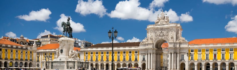
Praça do Comércio gives the system its most monumental riverfront expression. The former Terreiro do Paço had been associated with the royal palace and the machinery of empire. The rebuilt square retained the strategic waterfront location but recast it through regular façades, arcades and institutions linked to government and commerce. Its openness to the Tagus was not an ornamental accident. The square joined the representation of state power to the port economy on which Lisbon depended.
At the northern end, Rossio remained a civic focus with a longer pre-earthquake history. The grid does not erase it so much as connect to and frame it. Praça da Figueira, beside Rossio, acquired changing market functions and later structures; its present openness is itself a reminder that urban use does not stop evolving when a reconstruction plan is approved. The sequence from river square to commercial streets to northern civic spaces created an urban armature capable of absorbing later monuments, paving, shopfronts and traffic without losing its underlying logic.
Street width carried social and technical consequences
Wider streets aided circulation and commercial visibility, but their value after 1755 was also associated with safety, access and the separation of facing buildings. The lesson of fire was embedded in the preference for clearer routes and more controlled blocks. Yet it would be reductive to describe the grid as a single-purpose disaster response. It also staged views, improved the movement of goods, organized addresses and created more predictable development parcels.
The blocks reveal this mixed agenda. Long perimeter façades contain many separate properties or units, while party walls and internal divisions manage ownership behind a coordinated exterior. The ground plane is porous where commerce requires doors and display. Upper levels are more repetitive because stacked windows express recurring room and floor structures. The city’s rationality is therefore both visual and transactional: a regulated exterior makes a complex property and commercial system appear coherent.
One consequence for today’s visitor is that the grandest axis is not always the best place to study the system. Rua Augusta communicates the district’s urban force, but its signs, crowds and heavily adapted shops can obscure building detail. Quieter parallel and cross streets often make the repeated bay, party-wall spacing, corner treatment and shifts in street width easier to compare. A serious reading moves between ceremonial and ordinary streets because the plan was designed to include both.
The gaiola was an internal three-dimensional structure
The most famous technical element of Pombaline construction is also the least available to casual inspection. The gaiola pombalina, literally the Pombaline cage, was a timber framework incorporated within the upper parts of masonry buildings. Rather than acting as a decorative lining, it connected walls and floors into a more integrated three-dimensional system. Diagonal bracing, often described through the cross of Saint Andrew, helped framed wall panels resist deformation. Timber floors and orthogonal internal walls tied the assembly together.
A recent scholarly account describes the cage as an anti-seismic system intended to dissipate earthquake energy within the rebuilt lower city. The wording matters. “Anti-seismic” does not mean invulnerable, and the historical system should not be assigned a modern performance rating without investigation. It means that seismic behavior was consciously addressed through an internal structure whose continuity and flexibility differed from unconnected heavy masonry. The argument and its European context are set out in the 2024 study of the Pombaline cage.
In a typical Pombaline arrangement, the lower level used robust masonry piers, arches or vaulting suited to shops, storage and the loads above. From the first floor upward, timber-framed internal walls could be filled with masonry and joined to exterior and party walls through the floor structure. Details varied, and surviving buildings have endured repairs, moisture, fire, decay and remodeling. The essential principle is continuity: walls should not behave as isolated vertical planes if floors and crossing frames can help distribute movement.
This is why a façade photograph cannot prove that a cage survives behind it. A building may retain its Pombaline bay rhythm while having lost portions of the timber frame to new staircases, service shafts, concrete slabs or enlarged rooms. Conversely, significant timber fabric may survive behind a façade whose plaster, railings or ground floor have changed. Structural identification requires drawings, inspection or documented conservation work, not confident guesswork from the pavement.
The system depended on connections, not just diagonal timbers
Popular diagrams often reduce the gaiola to one wall panel crossed by two diagonal braces. That image is helpful but incomplete. A brace matters because it belongs to a network. Orthogonal walls, floor joists, perimeter masonry and joints between elements determine whether the building acts as a box or breaks into less stable parts. The three-dimensional relation is therefore more important than the picturesque form of one timber cross.
The masonry infill also complicates the common opposition between “flexible timber” and “rigid stone.” The system was composite. Timber provided tensile capacity, continuity and a degree of deformability; masonry supplied mass, enclosure, compression resistance and fire separation in particular locations. Performance depended on geometry, workmanship, material condition and how later interventions altered load paths. There was no single cage detached from the rest of the building.
A 2023 peer-reviewed study of Lisbon’s historic building classes is especially useful here because it distinguishes Pombalino construction from later Gaioleiro and Placa types. It describes masonry-infilled timber frames linked to orthogonal walls and timber floors to form the Pombaline three-dimensional system. The study can be read in the comparative research on Lisbon building typologies. The distinction prevents a common error: treating any old Lisbon building with timber as a fully preserved Pombaline cage.
Gaioleiro buildings, associated mainly with later nineteenth- and early twentieth-century expansion, inherited timber-and-masonry practices but often used different proportions, heights, layouts and levels of structural integration. Placa construction introduced reinforced-concrete floor slabs and belongs to another technological phase. A streetscape may include more than one of these systems, especially near the edges of the Pombaline core or where replacement followed later damage. Age, façade style and structural type therefore need to be tested separately.
Building type turned regulation into everyday architecture
The Pombaline building is best understood as a repeatable urban type rather than a single model copied without variation. It generally combines a commercial ground floor, several upper storeys, a controlled façade rhythm, shared party walls and a roof or attic zone aligned with the street composition. Corner plots, wider streets, institutional uses and churches required adjustments. The power of the type lies in its capacity to vary without dissolving the district’s coherence.
Façade hierarchy expressed floor hierarchy. Openings at the principal level could receive greater emphasis, while upper levels were simplified. Stone surrounds, plastered wall planes, iron balconies and cornice lines created disciplined repetition. The exact appearance visible today may reflect later replacement, but the underlying composition still helps explain how individual rooms and floors were presented to the street. A façade was a diagram of ordered occupancy.
The ground floor presented a special structural and commercial challenge. Shops needed broad access and usable interiors, while the upper building required support. Masonry arcades, piers and vaulted zones could carry loads and compartmentalize risk. At the urban scale, continuous shopfronts sustained the economy of the rebuilt centre. At the building scale, the transition from heavy lower structure to framed upper walls had to be carefully organized.
Standardization also changed the meaning of architectural authorship. The district was not composed as a sequence of isolated masterpieces. Its achievement is cumulative. A modest bay matters because hundreds of related bays establish the street wall; a corner matters because it resolves two regulated elevations; a party wall matters because it coordinates adjoining properties. Baixa’s architecture is strongest when read at several scales at once: joint, room, building, block, street and square.
This cumulative logic makes claims of absolute uniformity misleading. Differences in plot width, rebuilding date, patronage and later intervention were present from early on. Churches inserted into the grid, public buildings, corner conditions and the monumental fronts of Praça do Comércio all depart from the simplest house type. The system tolerated hierarchy. What it resisted was uncontrolled irregularity along the public realm.
Visible order and hidden structure are not the same evidence
For architecture travelers, the most important discipline in Baixa is to say what can and cannot be known from a given position. From the street, one can verify alignment, block rhythm, width relationships, the stacking of openings, arcades, corners and the continuity of major spaces. One can often identify later shopfronts, roof additions or conspicuously altered bays. One cannot reliably confirm the completeness of a timber cage, the condition of concealed joints or the originality of every floor.
This distinction is not pedantry. It changes the historical claim. “This is a Pombaline façade type” may be reasonable when supported by location and composition. “This building contains an intact eighteenth-century gaiola” demands a different level of evidence. The first is an architectural reading; the second is a statement about concealed material. A careful guide, conservator or historian should mark the boundary rather than smoothing it away.
The most productive site method is a sequence of hypotheses and checks:
- Begin with the plan. Establish whether the block belongs to the designed Pombaline grid, a pre-existing edge condition or a later extension.
- Read the elevation. Compare bay spacing, floor emphasis, corner treatment, cornice and roofline rather than relying on paint color or decorative freshness.
- Look for discontinuity. Enlarged shop openings, misaligned floors, added storeys, new balconies and abrupt material changes can signal intervention.
- Separate type from fabric. A building may preserve the type while replacing substantial material, or preserve hidden fabric beneath an altered surface.
- Use documents for concealed claims. Surveys, conservation reports, measured drawings and inspected interiors carry more weight than visual resemblance.
This is the point at which specialist interpretation materially changes the visit. The district’s defining structural system is mostly hidden, and its urban logic is distributed across several scales. A knowledgeable private guide can place archival plans beside specific sightlines, identify where a claim is secure or provisional, and prevent a sequence of similar façades from collapsing into visual monotony. For travelers who want that level of study within a tailored day, private Lisbon touring with specialist context creates a useful framework rather than a generic walk. Inquire now when the purpose is to connect street evidence, building typology and the documentary record in one coherent reading.
Later alteration is part of the evidence, not an embarrassment
Baixa did not become a museum after reconstruction. Buildings were adapted to new retail formats, sanitation, lighting, offices, hospitality, fire standards and changing household patterns. Owners combined rooms, cut openings, replaced floors, inserted lifts and services, rebuilt roofs and altered ground floors. Some interventions preserved the street façade while transforming the interior; others changed the external rhythm. The district’s continued economic use is one reason it survived, but use also changed the very fabric historians seek to understand.
The correct question is therefore not “Is this building original?” as though originality were a single switch. It is “Which layers survive, and at what scale?” A building may retain its eighteenth-century plot and party walls, a largely Pombaline façade composition, fragments of gaiola, a nineteenth-century roof and a twenty-first-century shop interior. Each layer answers a different question. Conflating them produces either romantic overstatement or an equally unhelpful declaration that nothing authentic remains.
Several familiar features of Baixa are later than the core reconstruction. The monumental Arco da Rua Augusta belongs to the nineteenth-century completion of the riverfront composition. Rossio’s wave-pattern paving and central monument are later transformations of an older civic space. The Santa Justa lift, visible near the western edge, is an early twentieth-century insertion. These additions do not cancel Pombaline planning. They demonstrate that a strong armature can receive new urban symbols while retaining its principal alignments.
Ground-floor commerce has produced some of the hardest alterations to read. Large display windows can remove or obscure the proportions of earlier openings. Signs and cladding may cover stonework. Interior walls may be cut to create continuous retail floors. A façade that appears orderly above eye level can therefore conceal major structural changes below. Conversely, an unassuming or altered shop may sit within a block whose party-wall and upper-frame logic remains significant.
Conservation presents a difficult balance. Retaining timber fabric is desirable, but degraded wood, incompatible past repairs and current safety requirements cannot be ignored. Replacing a floor with a heavier system may affect masonry walls and seismic behavior; removing partitions that belong to the cage can weaken three-dimensional action; inserting rigid elements can shift forces in unexpected ways. These are engineering judgments, not aesthetic preferences. The historical lesson of the gaiola is precisely that connections matter.
Carmo records rupture; Baixa records organized response
The Carmo church is indispensable because it prevents the reconstructed city from making 1755 seem abstract. According to the Carmo Archaeological Museum’s building history, the earthquake and subsequent fire left the Gothic entrance portal and the chevet area standing. Reconstruction began in January 1756 in a Neo-Gothic mode but was later suspended. The museum’s account is available through its institutional history of the Carmo church.
From Baixa, Carmo rises on the western slope as both topographic marker and evidentiary counterpoint. The lower city’s regularity can be read as an answer to the condition embodied by the ruined nave. Yet the two sites should not be forced into a simple before-and-after picture. Carmo itself was altered, partially reconstructed and curated as an archaeological setting. Baixa contains older traces, later repairs and replacements. Both are layered; they simply make different layers dominant.
The most revealing comparison concerns visibility. At Carmo, structural failure and survival are exposed: piers, arches, portal, chevet, absence of roof. In Baixa, the critical structural response is concealed within occupied walls. One site communicates through incompletion, the other through repetition. Studied together, they turn the earthquake from a dramatic episode into an architectural problem: how does a city remember destruction while continuing to function?
The Museum of Lisbon supplies the missing pre-earthquake comparison
Present-day Baixa cannot show the urban fabric it replaced. For that, a model, plan or image is necessary. The Museum of Lisbon identifies its model of Lisbon before the 1755 earthquake as an emblematic object and presents the rationalism and Enlightenment character of the Pombaline reconstruction as a central theme. The museum’s own guide description is available on the Museum of Lisbon highlights page.
A pre-earthquake model should be treated as an interpretive instrument, not as a neutral time machine. It helps establish contrasts in street regularity, density, waterfront form, major religious buildings and the royal complex. It can make the scale of urban replacement intelligible in a way that surviving fragments cannot. At the same time, the model depends on historical sources and curatorial choices. Its value lies in disciplined comparison: which spatial relationships are documented, which are reconstructed and which are simplified for legibility?
The comparison corrects two common assumptions. First, the pre-1755 lower city was not merely picturesque disorder waiting for modern reason. Its lanes, churches, palace, quays and markets embodied accumulated functions and histories. Second, the Pombaline grid did not create Lisbon from nothing. It reorganized a strategic site whose river access, civic centrality and economic importance long predated the earthquake.
That longer duration is worth keeping in view. Roman Lisbon beneath the later streets reveals an earlier relationship among slope, port and urban infrastructure. The Pombaline project is one unusually legible intervention within a city repeatedly rebuilt over older systems. Its originality becomes clearer, not weaker, when it is placed within that sequence.
A block-by-block reading of Baixa
A productive architectural study does not need to cover every street. It needs a sequence that tests different claims. Begin at the Carmo area, where the ruin and elevated position establish the rupture and give a partial overview of the lower city’s ordered roofscape. Descend toward Rossio and pause before entering the grid. From here, the northern civic space can be read as an inherited focus that the reconstruction connected to rather than erased.
At the edge of Rossio, look for the transition from the broad square to the disciplined street wall. The question is not which façade is prettiest. It is how repeated openings turn many properties into a continuous urban front. Note where corner buildings address two spaces, where ground floors have been enlarged and where upper levels retain a more consistent rhythm than the shops below.
Move into one of the north–south streets and compare it with a narrower east–west cross street. The change in width alters light, view, pedestrian pressure and the visibility of façades. On a principal route, the long axis dominates. On a cross street, the block depth and repetition of corners become clearer. This alternating view is the easiest way to understand hierarchy without relying on a plan alone.
Rua Augusta should be read as a civic-commercial axis rather than as proof of untouched eighteenth-century fabric. Its current pedestrian life, signage and later arch are part of the scene. The Pombaline evidence lies in alignment, width, the sequence of blocks and the relationship to Praça do Comércio. Parallel streets can then be used as controls. Where do bay widths repeat? How do balconies change? Does the roofline remain continuous? Which ground floors have disrupted the vertical supports implied above?
On quieter streets such as sections of Rua dos Douradores, Rua dos Correeiros or Rua dos Fanqueiros, the ordinary building type becomes easier to see. These are not lesser examples; they reveal the system’s everyday reach. Look above the shop signs. Window stacks often disclose internal floor levels. Party-wall intervals can sometimes be inferred from repeated vertical groups. Corner chamfers or returns show how the type negotiates intersections.
Praça da Figueira adds the evidence of lost uses. The present space has changed substantially, and its market history cannot be recovered from the current paving alone. That gap is instructive. Urban history includes structures removed within the life of the Pombaline plan. A square can preserve location and function imperfectly while its buildings change entirely.
End at Praça do Comércio, where the reconstruction expands from repetitive private fronts into a monumental public composition. The arcades unify long elevations and shelter the edge of the square; the river opens the fourth side; the equestrian monument and triumphal arch belong to later stages of symbolic completion. Stand far enough back to read the whole enclosure, then move under the arcades to see how the monumental order accommodates doors, offices and shops. The square’s achievement is the conversion of administration and trade into urban form.
What the route cannot prove
No exterior sequence can establish the structural state of a specific property. Even when a façade closely matches a Pombaline type, the cage may be partial, replaced or inaccessible. Nor can a street walk by itself reconstruct every decree, ownership dispute or construction phase. Its value is to organize questions and test visible consequences against documented intentions.
Interior access, when legitimately available through a museum, conservation project or documented building, can clarify the relation between partitions and floors. Yet one interior should not be generalized to every block. Details varied from the beginning, and later intervention varies even more. The responsible method moves from example to system cautiously, stating the basis for each inference.
Rational reconstruction was also an exercise of power
Baixa is frequently praised as an Enlightenment city: measured, regular, hygienic, commercially efficient and technically innovative. That reading is well founded, but incomplete. Rationality was not politically neutral. The ability to redraw streets, regulate elevations and direct rebuilding depended on concentrated authority after a disaster that had weakened ordinary negotiation. The same mechanisms that produced coherence also limited what individual owners could build along the public street.
This does not reduce the plan to authoritarian display. It sharpens the historical interpretation. Reconstruction had to solve collective-action problems that private building alone could not resolve: street continuity, fire separation, drainage, access, façade alignment and structural expectations. Strong direction could produce public benefits. It could also privilege certain economic uses, representations of order and property arrangements. Baixa should be read as both civic achievement and administrative project.
Commercial urbanism is central to that project. The lower city was not rebuilt merely to memorialize survival. It was rebuilt to transact. Shopfronts, warehouses, offices, customs functions, routes to the river and named commercial streets restored the circulation of goods and credit. Praça do Comércio’s very name announces the shift in emphasis from a royal palace square to a public image of mercantile government, even as state power remained highly visible.
The architecture makes this alliance material. Repetition reduces visual competition among individual buildings and enlarges the perceived order of the whole. Arcades bring separate premises under a common line. Street names classify trade. Regulated heights preserve a coherent urban wall. The city becomes a framework in which commerce can vary behind a stable public face.
Baixa’s engineering belongs to a wider Lisbon culture of infrastructure
The reconstruction is easier to understand when it is not treated as an isolated flash of genius. Eighteenth-century Lisbon was already investing in large systems that required surveying, hydraulic knowledge, masonry, administration and long-term coordination. The Águas Livres aqueduct and its distribution network addressed water supply at metropolitan scale. The Pombaline rebuilding addressed urban safety, commerce and construction at district scale. Their forms differ, but both reveal a government learning to make infrastructure visible through architecture.
Lisbon’s waterworks as an engineering sequence provides a useful comparison. The aqueduct announces load and span in stone; the gaiola hides flexibility inside plaster. One is monumental infrastructure crossing a valley, the other a repeated structural logic embedded in ordinary property. Together they complicate the idea that engineering history belongs only to bridges, towers and machines.
There is also a difference in how expertise appears to the public. An aqueduct arch can be admired without understanding hydraulic gradient. A Pombaline façade can be admired without seeing the cage. In both cases, interpretation connects visible form to invisible operation. That connection is particularly important in Baixa because the most photographed surfaces are not the strongest evidence for the system’s most original structural claim.
How to evaluate competing claims about Pombaline Lisbon
Architecture writing about Baixa often swings between celebration and skepticism. One account presents a fully standardized, earthquake-proof city created almost instantly by enlightened decree. Another emphasizes later alteration until the Pombaline label seems nearly meaningless. Neither position handles the evidence well. The first confuses intention with universal execution and survival; the second ignores the persistence of the plan, typology and documented structural fabric.
A stronger evaluation uses claim-specific standards:
- For planning claims, compare the present grid with approved plans, municipal studies and the relation among Rossio, the riverfront and major streets.
- For regulatory claims, look for decrees, elevation rules, building types and evidence of coordinated implementation across properties.
- For structural claims, rely on inspected fabric, measured drawings and conservation research rather than façade resemblance.
- For commercial claims, read ground-floor form, street naming, port access and the institutional role of Praça do Comércio while allowing for later changes in tenancy.
- For survival claims, identify the scale under discussion: plan, parcel, wall, façade, frame, floor, roof, finish or use.
This method also clarifies the status of the word “Pombaline.” It can describe a political period, an urban plan, a façade language, a building type or a structural system. Those meanings overlap, but they are not interchangeable. A building can stand within the Pombaline grid without retaining a complete gaiola. A later façade can follow Pombaline proportions. A surviving timber frame can contain repairs from several centuries. Precision is not a retreat from the term; it makes the term useful.
The interpretive payoff: Baixa is a protocol written as a city
The deepest lesson of Baixa is not that straight streets replaced crooked ones. It is that reconstruction was organized as a protocol. Survey established the field of action. Policy selected among possible urban futures. Regulation converted the selected plan into obligations for many sites. Building types translated those obligations into repeatable architecture. The gaiola addressed structural continuity within the building. Street hierarchy and squares connected construction to movement, commerce and state representation.
Seen this way, the district’s apparent restraint becomes intellectually dense. A repeated window bay is evidence of coordination; a wider street is evidence of hierarchy; an arcade is both architectural order and commercial shelter; a concealed diagonal timber is part of a seismic strategy; a later shopfront is proof that the regulated city remained economically active. None of these elements tells the whole story, but together they form an evidence chain.
The chain also explains why Baixa should not be judged solely by the amount of untouched eighteenth-century material. Material survival matters greatly, especially for structural history, but the urban project exists at several scales. Even where a building has been heavily altered, its plot, street line and relation to the block may continue to enact the reconstruction plan. Where original fabric survives, it adds a more intimate record of how that plan was built.
For a wider architectural day, a Lisbon sequence from historic monument to modern waterfront can place Pombaline Baixa within the city’s longer design history. Baixa contributes something distinct to that sequence: not a single landmark style, but a coordinated answer to failure. Its achievement is the conversion of loss into rules, and rules into an urban fabric flexible enough to remain central to Lisbon while still revealing, to a careful reader, how it was remade.
If you’re interested in any private tours of Lisbon, please reach out to us.


 So if you are looking for the absolute best in Lisbon & surroundings with authentic local fully-licensed native guides whose English you can actually understand and with an exclusive and amazingly fun itinerary